Image
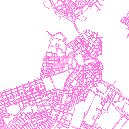
Map services can also export the map as an image.
http://gis.cityofboston.gov/arcgis/rest/services/Infrastructure/OpenData/MapServer/export?
bbox=-71.087379,42.348324,-71.041031,42.370142
&bboxSR=4326
&layers=show:0
&size=256,256
&imageSR=102100
&format=png
&transparent=true
&f=image
Filter Images
Using the layer definition you can generate a filtered image view.
http://gis.cityofboston.gov/arcgis/rest/services/Infrastructure/OpenData/MapServer/export?
bbox=-71.087379,42.348324,-71.041031,42.370142
&bboxSR=4326
&layers=show:0
&layerDefs={ "0" : "SURVEY='MISSING SURVEY'"}
&size=256,256
&imageSR=102100
&format=png
&transparent=true
&f=image